


Brute Magnetics
SKU: 24-GLOVESXL
Brute Magnetics Gloves for Magnet Fishing
$9.95
3 In Stock


Professional-Grade Geophysical Imaging System for Gold Exploration, Mineral Prospecting, Archaeology, Construction, and Void Detection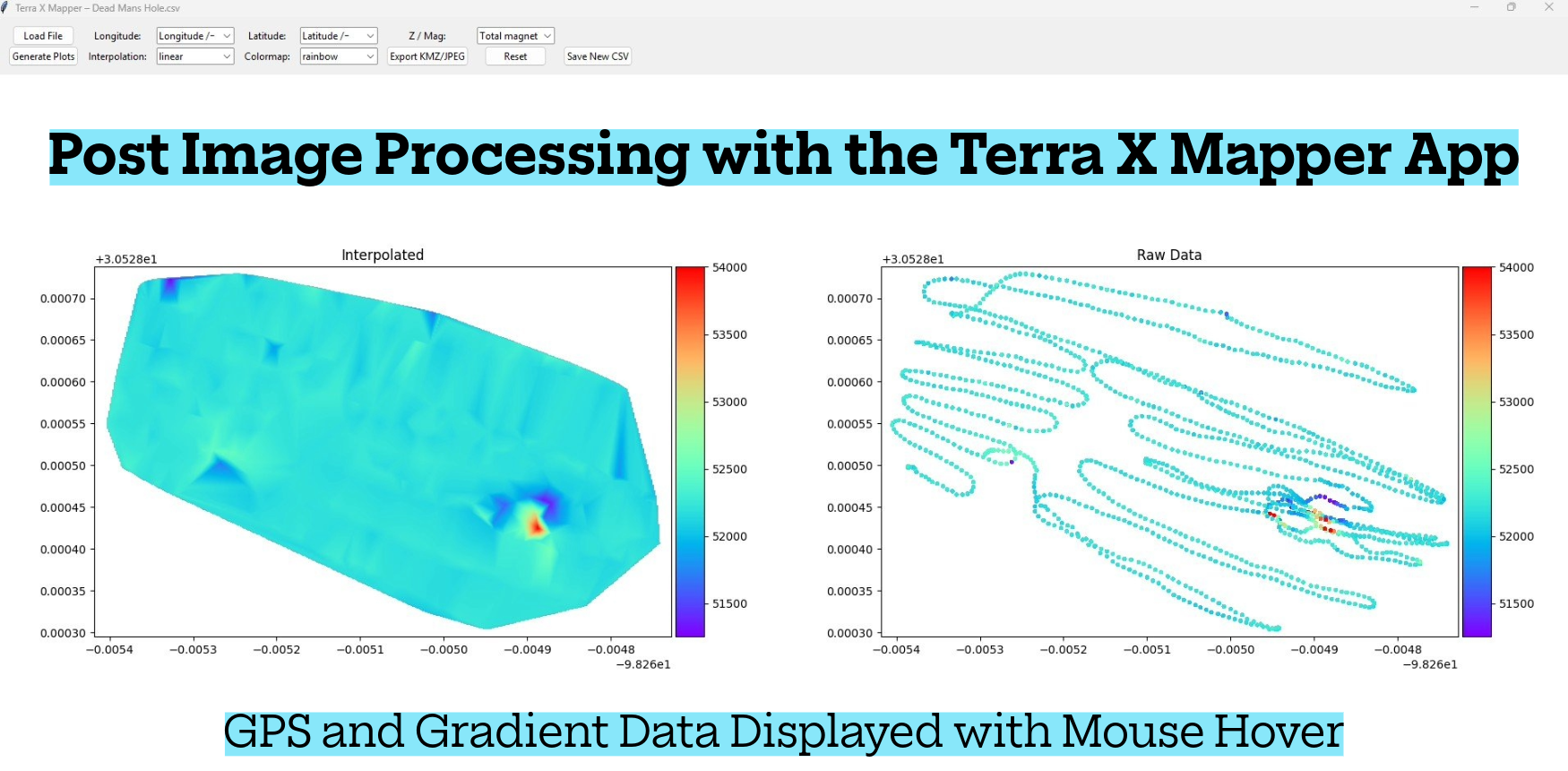
The MGM4000 is a portable, ground-based magnetic gradiometer designed for professionals who demand precision subsurface imaging beyond what traditional metal detectors can provide. Unlike conventional detectors that simply beep over targets, the MGM4000 maps underground geological structures, mineralization zones, buried features, and voids by measuring subtle variations in the Earth's magnetic field and displaying them as detailed visual maps in real-time.
This is not a point-detection device—it's a professional geophysical mapping instrument engineered to provide stable, repeatable gradient data for informed exploration and excavation decisions. Whether you're prospecting for gold, conducting archaeological surveys, planning construction projects, or searching for hidden voids and chambers, the MGM4000 reveals subsurface features that remain invisible to standard detection equipment.
Gold Prospectors & Mineral Explorers: Map buried paleo-channels, gold-bearing quartz veins, shear zones, and mineralized structures from 3-20 meters deep. The MGM4000 excels in highly mineralized soils and volcanic terrain where conventional detectors struggle.
Archaeologists & Historical Researchers: Locate buried foundations, walls, tombs, chambers, ancient structures, and disturbed ground with unprecedented clarity. The system detects both metallic and non-metallic archaeological features.
Civil Engineers & Construction Professionals: Identify subsurface voids, weak zones, buried utilities, old foundations, disturbed soil, and hidden obstacles before excavation begins. Essential for site planning, foundation assessment, and risk mitigation.
Treasure Hunters: Map buried caches, chambers, voids, and both magnetic and non-magnetic metals. The MGM4000 detects the disturbance left by burial—even when the metal itself produces minimal signal.
Water Well Contractors: Map fracture zones, fault-controlled aquifers, weathered bedrock, and buried paleo-channels that serve as productive groundwater targets.
Environmental & Geotechnical Consultants: Detect buried tanks, drums, infrastructure, and contamination-related features for site assessment and remediation planning.
The MGM4000 operates as a passive geophysical imaging instrument—it does not transmit signals into the ground. Instead, it precisely measures natural variations in the Earth's magnetic field caused by subsurface features.
The Physics: Everything underground that differs magnetically from surrounding soil creates a subtle disturbance in the Earth's magnetic field. The MGM4000 employs dual low-SWaP magneto-inductive vector magnetic sensors in a fixed-baseline gradiometer configuration to measure first-order magnetic field gradients. By comparing measurements taken at slightly different positions as you walk survey grids, the system identifies patterns that reveal:
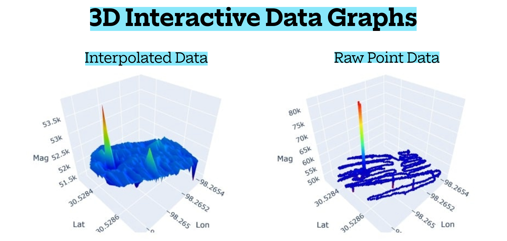
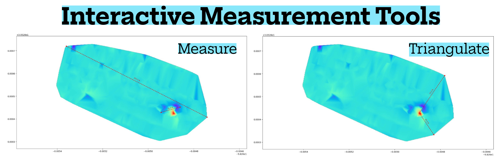
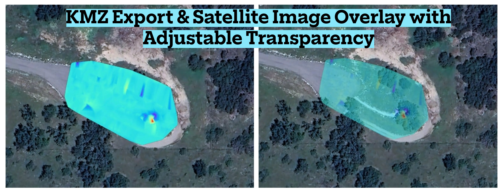
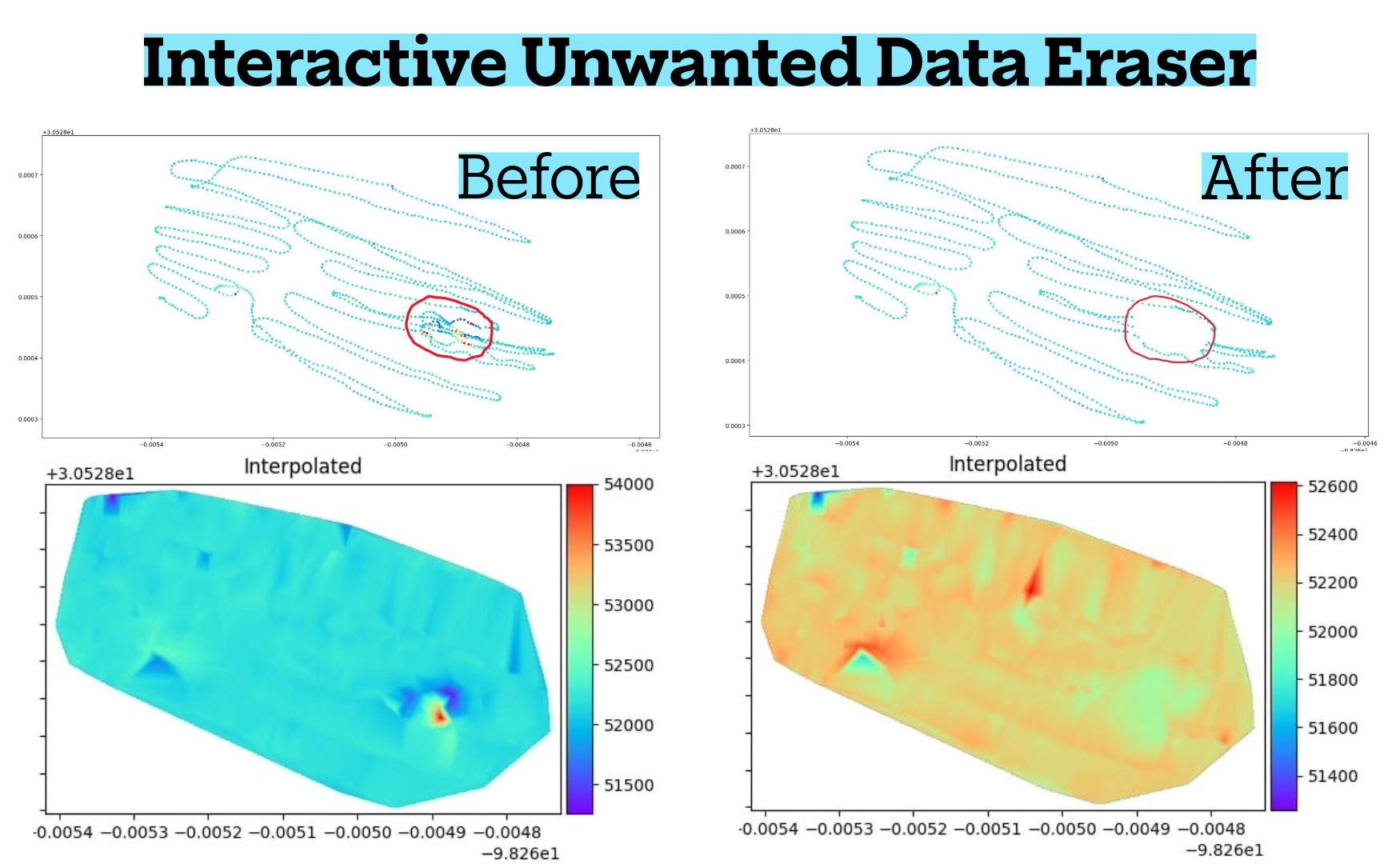
Real-Time Mapping: Data is displayed instantly as color-coded heatmaps, contour maps, profile lines, and depth-related anomaly indicators. You see exactly where anomalies are located, their size, depth characteristics, and spatial behavior—no guesswork, no unreliable audio tones.
 Depth Estimation: Depth comes from physics, not arbitrary guessing. The system analyzes anomaly strength, field change rate, and disturbance width to estimate target depth. Shallow objects produce sharp, intense signals while deeper targets generate broader, smoother signatures.
Alluvial/Placer Gold Systems:
Gold-Bearing Quartz Veins:
Shear Zones & Fault-Controlled Gold:
Hard-Rock/Lode Gold Systems:
Site Planning & Ground Condition Assessment:
Foundations & Structural Planning:
Roads, Highways & Infrastructure:
Utilities & Buried Infrastructure:
Natural Caves & Karst Cavities:
Abandoned Mines & Tunnels:
Tombs, Burial Chambers & Crypts:
Chultuns, Cisterns & Storage Chambers:
Voids & Hidden Chambers:
Backfilled Pits & Disturbed Ground:
Non-Magnetic Metals (Gold, Silver, Coins):
Magnetic Metals (Iron Chests, Weapons):
Fracture Zones & Fault-Controlled Aquifers:
Weathered Bedrock Aquifers:
Buried Paleo-Channels:
 Sensor Technology
This high-rate oversampling configuration provides exceptional instantaneous sensitivity while maintaining stable gradient measurements during operator motion, ensuring consistent spatial sampling at typical walking speeds.
Target depth capability depends on size, magnetic susceptibility contrast, geometry, and background geology:
Contact Kellyco at (888) 535-5926 for complete package details, accessories, and configuration options tailored to your specific application needs.
Transparency is important. The MGM4000:
Brute Magnetics
SKU: 24-GLOVESXL

Fisher
SKU: 12-FX3
 30110368 Image 1")
Minelab
SKU: 237-30110368
 headphone socket, or connect a 1/8-inch to 1/4-inch Headphone Adaptor Cable (Part No. 3011-0369) to the threaded socket. A USB charging cable with magnetic connector is included.
*Note: The WM 09 when used with the 3011-0372 waterproof headphones or 3011-0369 waterproof headphone cable can be used in heavy rains. The module cannot be submerged in water.*
Battery Life: Approx. 30 hours per charge.")
Minelab
SKU: 237-30110491

Aquascan
SKU: 1323-DX1120
Start receiving news & exclusive savings today!